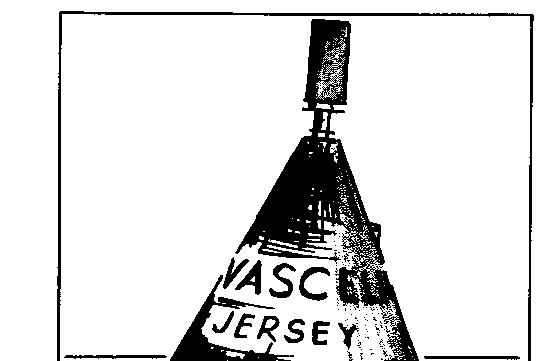
the Demie de Vascelin unlit buoy with a radar top. It must be left nearly 4 cables to the west when you can start sorting out from the maze of rocks spanning the southern horizon the first mark. This is line 324.
source "channel island pilot" par malcom robson
nautical publishing company ltd.
nautical house
lymington, hamshire SO4 9BA
(il est à noter que le plan
de Robson est assez peu précis et qu'en particulier le dernier alignement
à suivre pour atteindre le mouillage fait passer trop près du
sud de Maîtresse Ile : l'alignement 328 fait quitter trop tôt l'alignement
327)
When I first visited what the locals call the Minkies, it was a still, autumn day. Our boat safely at anchor, my companion went ormering while I climbed to the top of Maitresse île Five miles away to the west the Maisons beacon made a crown for its lion's head. The two of us were the only humans crawling about on this 25 square mile of pinnacle, sand bar and tombstone. A pale sun washed the pond-dead sea as in an empty well. In another six hours the picture would be turned back to front --rock heads leaving a slick on the mill race of the tide, the warm sand now down in the chill weedstrewn depths. Perhaps a thin fog drifts in from the east, dissolving the beacons. Or maybe a coming blow from the north grinds the swell into foam. Yes, I see the dinghy still safely tied-better get going if we want to be clear of this lot before dark.
Compared with the Ecrehous, the Minkies are less visited though better marked. No longer inhabited, the area is ten times as big. For the adventurous? Yes - but you must have one or two things right first. Settled weather and light winds - to be caught out in a blow could be serious. Visibility must be more than 1 1 miles; night work is out. Whilst Admiralty chart 2 100 is most useful there are many more heads than are shown. Chart T must be used with caution also, and I was in two minds whether to draw in the usual 3m. contour. However my line at least includes the trouble spots. Oh, one more item- an engine, one unlikely to stop.
Try to time your arrival not earlier than half tide down, which at springs means that most of the day can be spent ashore. Neaps are less traumatic, but this means an afternoon HW , so you may have to do without the breakwater provided by those 25 square miles of rockware. Probably your first visit will be from Jersey (technically you must clear there first) and in any case the southern approach is difficult to identify.
A century ago quarrymen built and lived in the dozen small stone houses, and for generations French and Jersey fishermen shared the harvest of the Minkies. Victor Hugo mentions them in the Toilers of the Sea, and Hammond Innes' recent novel, the Wreck of the Mary Deare is set there. Post war, though hardly a Struggle for Power, the sovereignty of the reef was decided between France and Britain at the Hague in 1953.
France lost her case and immediately whipped away all her magnificent buoys, leaving the States of Jersey to cope as best they could. Their old names like Brisants du Sud Caux and les Sauvages gave way to dull though more explicit points of the compass.
From St Heller it is 10 miles, course 172' and a useful departing mark is line 259, P- 12,5, for as long as you can see it. The passage is free of all dangers.
The key to' the entrance from the northward is View 322,
322 Demie de Vascelin
buoy
the Demie de Vascelin unlit
buoy with a radar top. It must be left nearly 4 cables to the west when you can start sorting out from the
maze of rocks spanning the southern horizon the first mark. This is line 324.
The far beacon is a white flagstaff and is hard to find at nearly 2 miles, but the profile of' Maitresse Ile is unmistakable --it is the only islet with houses. When a cable north of Jetée des Fontaines de Bas turn off to the SSW towards a miserable little beacon, line 325 Grune Tar, almost 8 cables distant. This leg, course 200°, is where, if you are sailing, it is time to lower sails and take to accurate transits. Don't wander more than five mètres either side, and have an anchor handy-in case you want to stop for a breather. By now the main transit, line 326 will show up. The pair of beacons is oil the same rock and only about 25 m. apart. This course, 164°, takes you within a metre or so off the drying sandbank eastward of' Grune Tar, so the beacons may be opened slightly-that is to the cast. It is then 8 cable to a stringy bean-pole beacon, les Demies, view 323, which must be rounded a cable off, southward, until, to the cast, line 327 will show. The front white mark 2 m. high, is outlined in funereal black, as is the 4 m. cross above it. This mark leads over a 1.2 rn. shoal and ill
fact from now on you are in a drying area. When les Demies bears north-west, line 328 will come on, and this leads into the anchorage. Either anchor when the beacon in view 329 bears 0° 15', or use the States of Jersey buoy at the same position, in the middle of the anchorage. This is laid for the States tug of 80 tons when on buoyage duty and it has triple mooring chains. If drying Out, the bottom is soft sand and mud, so don't fix legs. Now is the time to relax and decide whether to clear off on the rising tide or stop the night. Why not spend a day or so exploring this fascinating area? At low water most movement stops and a dinghy can be taken among the sand bars to your own uninhabited desert island. The strongest current, 4 knots, is about 2 hours before HW direction SE, so the States anchorage is reasonably sheltered. Long before this you must he aboard your boat, for at springs, only a powerful outboard would save you a scare. The States of Jersey have thoughtfully installed a refuge hut - a white column 6 m. high topped by a 2 m. square white hut with a ladderwith food, water and clothes, at Pipette rock, 49° 00.0' 2° 10.0' and on Maitresse Île there is a helicopter pad. This is an Anglo-French realisation in concrete 50 m. square, and alongside is built another store of food, water, etc., for emergency use.
Ashore on Maitresse Ile are a dozen stone houses, now occupied mostly by shags. There doesn't seem to be the same desire to populate here as in the Ecrehous. Landing is at the 80 m. long slip north-west of the States mooring buoy.
The States beacon, View 329, was built more to clinch territorial rights-it is better than the official flagstaff, as a 25-year-old photo of a notice board demonstrates. It was in French and English.
17-9-1947
The French flagstaff today remains some 100 m. to the south-west of the States of Jersey one-forlorn,
unpainted and forgotten.
In 18oo the quarrymen, busy hacking stone for Fort Regent, St Helier, had had enough. By 1807 they
petitioned the Governor of jersey to stop work before they were swept away. He didn't agree, so the men
emigrated to Chausey to work for the French. Until just before the last war, fishermen from la Roque,
Jersey, reckoned the Minkies were their exclusive grounds. Then was the time the famous Marin-Marie,
Chausey yachtsman and painter, built the French cabin which started the squabble about
sovereignty.
Should you want to sail on southward instead of going back to Jersey, leave about an hour before low
water. Retrace the route as soon as afloat, lines 328 and
327 but carry on west another cable until the two
beacons on Rocher du Sud Bas are open as on line 330 The opening between the beacons equals the
distance of the south beacon to the west head. Now comes a tricky bit; when a cable short of the rock
with its two beacons, make a handrail westabout until line 331
comes on. There isn't a view, but it is the
reciprocal of line 326, both beacons in transit. This mark takes you clear out to sea, but it must be held
accurately for at least three miles, which is why the approach from the south isn't easy to locate. Pass east
of the SE Minquiers buoy-there are drying rocks 4 cables north-westward. From here to St Malo is only 14
miles.